One key question in stream restoration is “What state are you restoring to?” The idea of shifting baselines— that our ideas of how streams should look like is based on current conditions, and can’t encompass previous massive land use changes like beaver removal—came into river restoration literature as well. In her 2006 article “Human impacts to mountain streams”, geomorphologist Ellen Wohl notes that because beaver occurred before European settlement of N. America, our cultural image of pristine streams is of streams unmodified by beaver. In the Salmon Creek watershed, where I am doing my dissertation work, beaver are currently absent, and the California Department of Fish and Wildlife considers them to be “non native nuisance species” because some beavers were reintroduced from Idaho during the 1940s. Anecdotally, most ecologists I’ve spoken to believe that beaver were present in the coast ranges, but were limited to valley bottoms because steep gradients limited their ability to build permanent dams in tributaries. Nonetheless, beaver ponds were likely critical refugia for juvenile salmonids during late-summer dry periods.
Pollock et al. characterize beavered and beaverless streams as alternate stable states (Figure 1), because following stream incision, flows are too high for beavers to establish permanent dams. In the beaverless state, streams become drier and are prone to erosion. But if beaver can gain a footing, “[their] dams measurably affect the rates of groundwater recharge and stream discharge, retain enough sediment to cause measurable changes in valley floor morphology, and generally enhance stream habitat quality for many fishes” (Pollock et al. 2003). That is, beaver dams could potentially reverse many of the problems that humans had caused in two centuries of logging, grazing, channelizing, dredging, and bulldozing streams. Perhaps most significantly for semi-arid and Mediterranean regions of the Western U.S., beaver dams could keep streams wetter longer, and create cool water refugia critical to endangered salmon (the NMFS Central Coast Coho Recovery plan mentions beaver reintroduction as a tool in recovery). And, compellingly, beaver did this while increasing overall productivity and species diversity, and at a very low cost to taxpayers.
Pollock, along with Joe Wheaton, Nick Bouwes, and Chris Jordan, work on Bridge Creek, an incised stream in eastern Oregon that was eroded, stripped bare of riparian areas, and too warm for salmonids. They wondered whether beaver dams could jump start recovery by trapping sediment and water and reconnecting the stream to its floodplain. Pollock and his collaborators then devised “beaver dam support structures”, posts installed downstream of beaver dams that could keep them from washing out at high flows, and introduced the idea of “collaborating with beaver for watershed restoration.” Later studies confirmed that beaver dams were recharging groundwater, cooling temperatures downstream, and creating diverse wetland habitat above their ponds, and created a five-fold increase in riparian area compared to undammed sites.
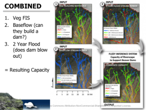
One outcome of this research is the Beaver Restoration Assessment Tool, a GIS based tool that melds information on stream power, gradient, and vegetation. The result is a spatially explicit map of beaver dam potential (Figure 2). The fuzzy inference system is used iteratively, first to construct the vegetation building materials layer, then to assess the capacity of riverscape to support beaver dams. An additional model can look at the effects of ungulate browsing on riparian vegetation on capacity.
Several key features of this model distinguish it from other approaches, notably GIS-based habitat suitability models and bottom-up agent-based models. Habitat suitability models identify all of the habitats that could be occupied by a species, given enough food, shelter, and rearing habitat. These models identify a maximum range, but for a generalist ecosystem engineer like a beaver that is also influenced by stochastic fluvial processes, may overestimate suitable habitat. By using fuzzy inference to think like a beaver, the algorithm can begin to trace causal linkages in key eco-hydrological processes that affect beaver dam building—the beaver behavior of interest to river restoration practitioners. However, unlike agent-based models, the BRAT does not attempt to model beaver dispersal to different sites nor the feedbacks between dam construction and hydrologic and vegetation shifts. The authors note that “An area that is not currently utilized one year and is at 0% capacity may be at 100% of capacity the next year simply because a dispersing beaver or a colony moved into that area. These fluctuations are an important part of the diversity, discontinuities and dynamics of beaver dam influenced systems…” but are not incorporated explicitly into the model (Macfarlane and Wheaton, 2013). Rather, dam capacity per kilometer is assessed in the GIS, and then validated using aerial and ground-based surveys of existing beaver dams.
Figure 2: Workflow of the BRAT fuzzy inference model, from Wheaton et al. 2013 (presentation) “Cheap and Cheerful Stream Restoration and Monitoring: An example of partnering with beaver in riparian repair” April 15, 2013.
The authors want BRAT to be used in decision making, but note that it must be combined with other qualitative and quantitative tools. The presence of predators and ungulates (which browse willows) could be incorporated quantitatively, but other factors, such as human predation and conflict should be assessed qualitatively, through in-depth interviews or community meetings. I could see using the tool on the Salmon Creek, where beaver are absent, to spark discussion among landowners and agencies about if and where beaver might be reintroduced with floodplain restoration in mind. Because no beavers currently reside in the watershed, such a model could not be validated—yet.
References:
Macfarlane WW, and Wheaton JM. 2013. Modeling the Capacity of Riverscapes to Support Dam-Building Beaver-Case Study: Escalante River Watershed. Ecogeomorphology and Topographic Analysis Lab, Utah State University, Prepared for Walton Family Foundation, Logan, Utah, 78 pp.
Pollock, M.M., J.M. Wheaton, N. Bouwes, and C.E. Jordan. 2011. Working with Beaver to Restore Salmon Habitat in the Bridge Creek Intensively Monitored Watershed: Design Rationale and Hypotheses, Interim Report. NOAA Northwest Fisheries Science Center: Seattle, WA. 63. pp.


